Mountain Biking Information
Wilkins Peak Biking Trail System

Wilkins Peak Bike Trail System was voted "#1 Best Mountain Bike Trail in Wyoming" and "The Most Popular Mountain Bike Trail in Wyoming" for four consecutive years in a row by SingleTracks.com beating out 238 other Wyoming bike trail systems. SingleTracks.com also ranks Wilkins Peak Bike Trail System #71 out of all the world's bike trail systems.
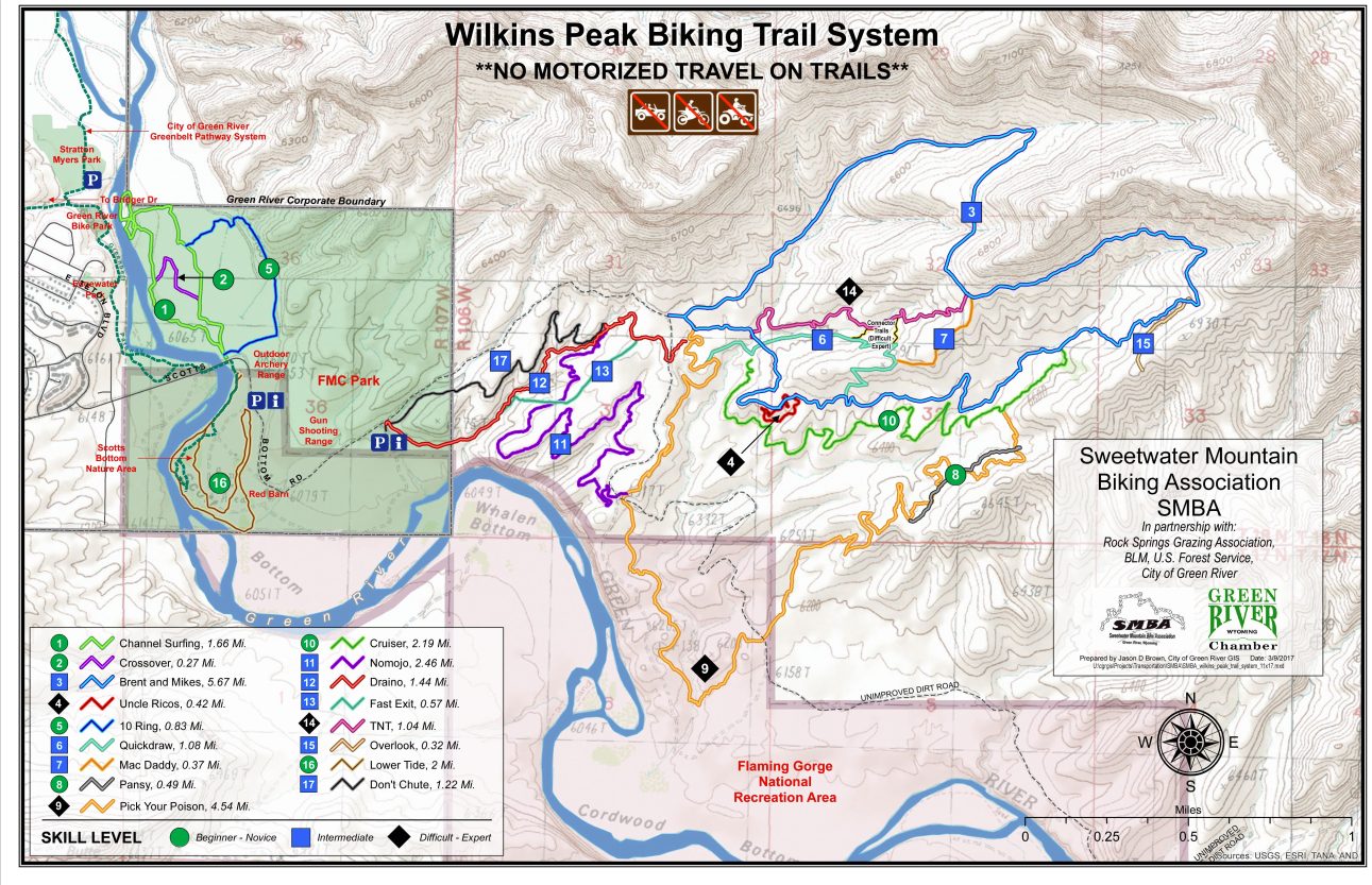
Above is the Wilkins Peak Bike Trail System map, highlighting each trail and listing them from Beginner to Expert. For a printable PDF version of this map click here.
Our local Sweetwater Mountain Biking Association encourages responable mountain biking and protection of natural resources. You can visit their facebook here and their website here.
Directions: From Interstate 80, take exit 91 Green River/WY-530/E Flaming Gorge Way, Merge onto E Flaming Gorge Way, take ramp onto Uinta Dr., turn left onto Astle Ave., keep following Astle Ave. which turns into E. Teton Blvd. (You will pass through a neighborhood) Take a left onto Scotts Bottom Rd. You will drive over a bridge and vear right at the bottom. Keep following Scotts Bottom Road pass the Red Barn on your right and the Gun Shooting Range on your left. The trail head is about 100 yards past the shooting range.
For a digital map with directions to Wilkins Peak Bike Trail System click here.
Trails
Beginner
Channel Surfing -
Beginner/Novice
1.66 miles
Typical Ride Time: 20 minutes
Crossover -
Beginner/Novice
.27 miles
Typical Ride Time 5 minutes
10 Ring -
Beginner/Novice with some intermediate and difficult sections
.83 miles
Typical Ride Time: 20 minutes
Description:
On Channel Surfing and Crossover the trail parallels the Green River bottom
along an easy trail. Ground can be soft and sandy in the spring and fall and will in some areas
become a bit more packed. This is typical river bottom ground with grasses, sage brush, and
cottonwood trees closer to the river. Portions of the trail are overflow channel for the river which
may become impassable with spring runoff and high water during the spring. Crucial junctions to
be aware of are the intersections with The Crossover Trail about 1/2 mile from the trail head and
the 10 Ring Trail on the northeast side of the trail about 1 mile from the trail head.
10 Ring trail winds its way along the foot of the bluffs above the Channel Surfing Trail with some
intermediate trail sections and several difficult drops, those can be avoided if you choose. Crucial
junction to be aware of is where the trail crosses Channel Surfing approximately 1 mile from the
the main trail head. Key feature to this trail are the drops and wooden crossing which add a unique
challenge to this twisting trail. Both trails offer great views of the river, the City of Green River and
surrounding bluffs. This area has numerous wildlife viewing opportunities such as deer, moose,
pronghorns, beaver, muskrat, raptors and fish.
Directions:
To get to the trail head of Channel Surfing, 10 Ring and Crossover trails begin on
the north side of Scott’s Bottom Road after crossing the river bridge. They can be easily
accessed from Parking A next to the Outdoor Archery Range. Channel Surfing trail heads
northwest along the river bottom and then turns due east to hook up with the 10 Ring Trail.
The 10 Ring Trail also begins on the north side of the Scott’s Bottom Road after crossing the
river bridge. The trail turns east uphill and then turns north an then back west to connect up
with the Channel Surfing Trail. Crossover Trail connects to the two east and west legs of the
Channel Surfing Trail approximately 1/2 mile from the trail head.
GPS Coordinates:
N. 41⁰ 29’792” W: 109⁰ 26’269”
Pansy -
Beginner/Novice
.49 miles
Typical Ride Time: 15 minutes
Description:
Pansy is part of Pick Your Poison trail. It provides less technical option for riders wishing to avoid a
more difficult waterfall climb on Pick Your Poison. It also provides an easier climb coming from
Brent and Mikes as you head back on Pick Your Poison to its trail head.
Brent & Mike’s Trail -
Easy to moderate challenging
5.67 Miles
Description:
This trail, begins as a two track with a long gradual uphill climb the first 2 miles then
flattens out with a very slight vertical gain the remainder of the ride. This is a perfect out and back ride.
At approximately the 3 mile point you will come to an intersection, go to the left of the fork and it will
take you to a great viewpoint. The right fork takes you to the more challenging down hills, blasting
through cedars, rolling over rock slabs, small drops and a thrill ride down a wash, all of which will bring
you back to the start point.
Intersections: 2.1 mile - MacDaddy
3 mile - left fork to Lookout
3.6 mile - Pick Your Poison
4.8 mile - Uncle Rico
5.4 mile - Quick Draw
Directions:
The trail begins at Parking Lot C.
GPS Coordinates:
N41⁰ 29.767’ W109⁰ 26.307’
Cruiser -
Beginner/Novice
2.19 Miles - (1.32 one way)
Typical Ride Time: 20 - 30 minutes
Description:
Cruiser Trails is a beginner trail with a few intermediate technical spots that are
easily walked over or around. The trail follows the base of the hillside and has no long sustained
climbs and little net elevation gain. Cruiser can be ridden as an out and back ride, or connected
with other trails to make longer or shorter loops.
Directions:
To get to the trail head follow Pick Your Poison from the trail head to Quickdraw Trail,
Cruiser Trail splits to the right off of Quickdraw after crossing the wash.
GPS Coordinates:
N41⁰ 29.795’ W109⁰ 24.468’
Intermediate
Draino -
Intermediate - some technical terrain and climbing
1.05 miles
Typical Ride Time: 20 minutes
Description:
This trail can be ridden two ways. Use it as the beginning of your ride at Parking
Lot B as described above. Draino is the primary gateway to the Wilkins Peak Trail System. The wash
ride varies in surface from shale, sand or rock often depending upon previous rain storms. Staying
on Draino after the NoMoJo junction continue straight ahead. The trail climbs steeply for another
1/4 mile until the maximum elevation of Draino has been achieved. Once out of the wash canyon
you’ll meander east and south across the plateau where the trail crosses Forest Service Road 171,
which brings you to the junctions of Brent & Mike’s Trail and Pick Your Poison. If you have already ridden the trails that
connect Pick Your Poison with Brent & Mike’s then you’re ready to head back down.
Here is the second way; use Draino for an incredible downhill test of your suspension and be prepared
to giggle like a little girl when you get out of the canyon. Draino is a workout climbing up but an amazing
rush coming down, turning ledges you climbed up into launching pads and high banked turns flying down.
Directions:
To get to the trail head from Parking Lot B, (N 41⁰ 29.604’, W109⁰ 25.761’), start on
the Scott’s Bottom Road and turn right through a wash in front of you and follow a two track road
south around the hill, towards the river, working your way southeast to the canyon. Drop here
through the next ravine following the right fork up the canyon. Your next drop will be in the wash
where the trail meets Fast Exit coming down. Make a left turn and proceed up the wash as it makes
its way up. The trail will take the obvious forks in the wash and the trail stays in the wash until
climbing out and passing the upper trail head for NoMoJo Trail on the right.
GPS Coordinates:
N 41⁰ 29.577’ W 109⁰ 25.497’
NoMoJo Trail -
Intermediate - some technical terrain and climbing
2.46 miles
Typical Ride Time: 20 minutes
Description:
The first .40 miles of this trail have several spots of exposure and some technical
sections. If this kind of riding is not your cup of tea do not be discouraged. The remainder of the trail is
smooth with amazing views of the Green River and some beautiful deep canyons. This is a very flat trail
with only 170 feet of elevation gain.
After negotiating the technical section of this trail you will cross the Fast Exit Trail at .44 miles. Stay
straight ahead, at .73 miles stop and enjoy the views of the Green River before starting up the next
canyon. Follow the trail into two canyons until crossing a two track dirt road at mile 2.10 miles. You will
then come to a wash crossing that will challenge most intermediates. The trail then starts ascending,
crossing Forest Service Road 171 at 2.40 miles, this is the end of the trail and junction to Pick Your Poison.
Directions:
This trail starts at Draino and ends at Pick Your Poison.
GPS Coordinates:
Starting: N 41⁰ 29.866’ W 109⁰ 24.985’
Ending: N 41⁰ 29.420’ W 109⁰ 24.907’
Mac Daddy -
Intermediate
.37 Miles
Typical Ride Time: 10 minutes
Description:
This is a fast, side hill, roller coaster trail that can be linked to Quickdraw for an
even more extended downhill. If a person chooses to climb Quickdraw, Mac Daddy will link into
Brent and Mikes. Mac Daddy allows the rider to custom design the ride providing loop access to
several trails within the Wilkins Peak Trail system.
Directions:
Mac Daddy is a connector trail linking Brent and Mikes with Quickdraw. To access
this trail for a fast downhill run, ride up Brent and Mikes until you see the junction sign for
Mac Daddy.
GPS Coordinates:
N41⁰ 29.961’ W109⁰ 23.684’
Quickdraw -
Intermediate
1.15 Miles
Typical Ride Time 30 - 40 minutes
Description:
Quickdraw is an intermediate trail that climbs up and over the ridge before
connecting to Brent & Mike’s Trail. Cruiser Trail is also accessed off of Quickdraw Trail. The
majority of the trail is packed single track with a few small rock gardens. Quickdraw makes a
sustained climb up the ridge with a few tight switchbacks before descending the other side and
connecting to Brent & Mike’s Trail.
Directions:
From the main trail head follow Pick Your Poison for 1/4 of a mile to where
Quickdraw branches off to the left.
Fast Exit -
Intermediate
.57 miles
Typical Ride Time: 15 minutes
Descriptions:
The name of the trail says it all. This is the fast way to get back to the parking
area. From the top intersection of Draino, cruise along the ridge line for 28 miles before hanging a
right. Travel .34 miles, cross NOMOJO and continue straight down the hill where the trail becomes
steeper. Plan on hanging onto your brakes for a short, super steep, rutted section before
crossing the wash and the connection to Draino.
Directions:
Intersection of Draino and Fast Exit
GPS Coordinates:
Top Intersection of Draino & Fast Exit: N41⁰ 29.795’ W109⁰ 24.468’
Bottom (wash) where Fast Exit crosses Draino: N41⁰ 29.632’ W109⁰ 25.365’
Don’t Chute -
Intermediate climbing, off-camber and minimal exposure
1.22 miles
Typical Ride Time 15 minutes
Description:
This trail is an alternate route up if Draino becomes flushed. That‘s not to say that it’s not a great
warm up for getting to the upper trails. You start out on 2-track for about 0.2 miles, turning to singletrack at this point
you begin a steady climb up to the saddle in the ridge. From there on out you’ll remain at that level, weaving in and out
of several drainage formations with occasional sections of narrow singletrack, exposure and off-camber pedaling. At 1.2
miles you’ll intersect Draino and NOMOJO
Directions:
Intermediate climbing, off-camber and minimal exposure
Don’t Chute: This trail starts at Parking Lot B. Start on the Scott’s Bottom Road and turn right through the wash and
follow 2-track to the left of the buck rail fence. Proceed along the base of the ridge on the 2-track , which it will turn in
singletrack once you cross another 2-track . The singletrack will traverse up to a saddle in the ridge and at that point
you will be on 2-track again for just long enough to spot the rock cairn on the right. Follow this singletrack around until it
meets up with Draino & NOMOJO.
Expert
Pick Your Poison -
Advanced with some Intermediate sections
4.54 miles
Typical Ride Time: 1 hour
Description:
This trail offers options for both intermediate and advanced riders. Along this trail
there are many options that allow more advanced riders to challenge themselves but still allows others
to take a more mellow route. If you want to take the more difficult options follow the black markers.
Blue will be the easier route. This trail does have some sustained climbs that could prove difficult for
beginners but would be a good challenge for intermediates. Total elevation gain for this trail is 700 feet.
Trail description starts from Brent and Mikes and ends at Cruiser.
From Brent and Mikes junction and just past the first rock obstacle turn left at the junction with
Draino at .05 miles. At .31 miles will be the junction with Quickdraw, stay to the right and follow the
trail to the junction with NOMOJO at mile 1.09. You will cross two roads and enjoy the descent to the
wash crossing at mile 1.93. The trail now starts climbing for the next .3 miles with numerous bridge
crossings and some challenging switchbacks towards the top. At mile 3.2 stop and take a break and
enjoy the views looking to the southeast toward Flaming Gorge. The trails mellow out for a while until
the junction with Pansy at mile 3.5. Pansy is an easy option and is recommended for everyone except
advanced riders. Take a left here and see if you can clean the waterfall. Follow the Pick Your Poison signs
as Pansy joins it for a few short sections. There are numerous bridges and technical sections in this area.
At mile 3.94 the Pansy trails heads left, stay right to ride some more tight switchbacks and technical
sections. Finally at mile 4.22 descend into the wash with a quick climb and enjoy some nice mellow
rollers before the end of the trail at the junction with Cruiser at mile 4.41.
Directions:
The trail begins at Parking Lot C.
GPS Coordinates:
N 41⁰ 29.420’ W 109⁰ 24.907’
TNT-
Expert
1.40 Miles
Typical Ride Time: 30 minutes
Description:
If it’s a fast, fun, furious, free-ride to the bottom with tight turns and steeps that you’re after or a
free-flowing uphill to fulfill your fitness fix, either wat your heart will be pumpin’ on TNT. With two access trails
to/from Quickdraw and multiple side trails for an easier ride up or down, this trail system offers freedom and
flexibility for the free-rider in all of us.
Directions:
There are two access points off of Brent & Mike’s Trail.
GPS Coordinates:
N41⁰ 29.991’ W109⁰ 23.784’
Uncle Rico’s Trail -
Expert
.42 miles
Typical Ride Time: 15 minutes
Description:
Uncle Rico’s is designed to be a one-way loop off of Brent & Mike’s Trail. The trail
heads south down a wash. The first section is a fast downhill with ladder bridges and banked turns
followed by a short but very difficult climb. There are several switchbacks and some tricky sections
that make the trail a challenge. As you get back to the top of the trail you cross over Brent & Mike’s
and loop back around to the start of the trail.
Directions:
The trail starts off of Brent & Mike’s Trail, towards the end.
Green River Bike Park

Before you head out on Wilkins Peak Bike Trail, practice your moves at Green River Bike Park! Featuring technical elevated trails, pump track, dirt jumps, big berms, rock drops, teeter-totters and more. For more information click here.
Directions: From Hwy 80, take exit 91 Green River/WY-530/E Flaming Gorge Way, Merge onto E Flaming Gorge Way, take ramp onto Uinta Dr., turn left on Monroe Ave, stay straight when Monroe Ave. becomes dirt and enters Stratton-Myers Park, drive to end of the road and park. The Green River Bike Park is across the creek just south of the parking lot.

